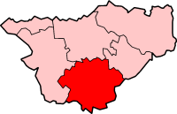
Crewe and Nantwich
Wygląd
Na mapach: 53°05′36″N 2°29′13″W/53,093200 -2,487030
| dystrykt niemetropolitalny | |
 Nantwich | |
| Państwo | |
|---|---|
| Kraj | |
| Region | |
| Hrabstwo | |
| Populacja (2001) • liczba ludności |
|
Położenie na mapie Cheshire
| |
| Strona internetowa | |
Crewe and Nantwich – były dystrykt w hrabstwie Cheshire w Anglii. W 2001 roku dystrykt liczył 111 007 mieszkańców[1].
Civil parishes
[edytuj | edytuj kod]- Acton, Alpraham, Aston Juxta Mondrum, Audlem, Austerson, Baddiley, Baddington, Barthomley, Basford, Batherton, Bickerton, Blakenhall, Bridgemere, Brindley, Broomhall, Buerton, Bulkeley, Bunbury, Burland, Calveley, Checkley cum Wrinehill, Cholmondeley, Cholmondeston, Chorley, Chorlton, Church Minshull, Coole Pilate, Crewe Green, Dodcott cum Wilkesley, Doddington, Edleston, Egerton, Faddiley, Hankelow, Haslington, Hatherton, Haughton, Henhull, Hough, Hunsterson, Hurleston, Lea, Leighton, Marbury cum Quoisley, Minshull Vernon, Nantwich, Newhall, Norbury, Peckforton, Poole, Ridley, Rope, Shavington cum Gresty, Sound, Spurstow, Stapeley, Stoke, Walgherton, Wardle, Warmingham, Weston, Wettenhall, Willaston, Wirswall, Wistaston, Woolstanwood, Worleston, Wrenbury cum Frith i Wybunbury[2].
Przypisy
[edytuj | edytuj kod]- ↑ Neighbourhood Statistics
- ↑ w 2001. [dostęp 2016-01-14]. [zarchiwizowane z tego adresu (2016-03-11)].
